11 Days/10 Nights April to December Moderate/Hard
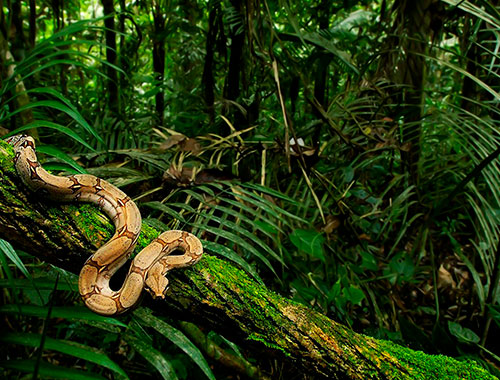
Choquequirao - The Lost City Trek: Beyond Machu Picchu lies a remote Wild region of cold high uplands and hot tropical valleys known as the Vilcabamba. The is a steep mountainous region of extreme relief that served as a jungle border province and later, last refuge for the Inca resisting the Spanish colonization of Peru. Altitudes vary from tropical river bottom canyons below 2000 meters to mountain heights on up to almost 6000 meters. Thick cloud forest vegetation covers much of the area up to around 4000 meters.
In the year 1536, three years after the fall of the Inca Empire to Spanish adventurers, Manco Inca, grandson of the last great ruler Huayna Capac, led a rebellion against the Conquistadors. Retreating from a failed siege of Cusco, Manco and his followers established court in this remote region maintaining vestiges of Inca tradition, religion and statehood out of reach of Spanish authorities. The Inca built a network of roads and trails connecting outposts, settlements, shrines and ceremonial centers, which Barry Walker first explored it 25 years ago when, still unknown and covered with forest. Now we offer this program as a unique adventure trek experience with pack mules, comfortable camps. Our ultimate goal is to visit the large Inca ceremonial site of Choquequirao, a distant replication of its more famous sister site Machu Picchu. Currently a stay at Choquequirao is like a visit to Machu Picchu in 1915 and more difficult to get to!
The expedition is 19th Century style using pack stock to carry supplies, camp and amenities. Our Quechua speaking packers supported by professional cooks insure comfortable, organized camps. Delicious meals and daily happy hour/tea are served in a dining tent. A pan of hot water with mug of coffee or tea served at your tent greets each day. We require that all participants be in good health and physical condition. We hike up to seven hours on some days.
Day 1: Cusco To Machu Picchu
Day 2: Machu Picchu to Huancacalle
Day 3: Vitcos and the White Rock
Day 4: Huancacalle To Choqueticarpo
Day 5: Choqueticarpo To Quelcamachay
Day 6: Colcamachay To Yanama
Day 7: Yanama To Maizal
Day 8: Maizal To Choquequirao
Day 9: Choquequirao
Day 10: Choquequirao To Chikiski
Day 11: Chikiski To Cachorra and Cusco
Day 1: Cusco To Machu Picchu
An interesting 4 and half hour bus and ride on the Orient Express tourist train takes us to our destination, Machu Picchu and the bustling town of Aguas Calientes located some 2,000 ft, below Hiram Bingham's great 1910 discovery.
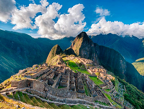
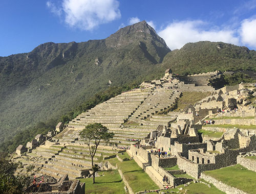
MACHU PICCHU, one of the most magical and mysterious places on Earth! Situated on the spine of a jungle cloaked granite peak towering some 2,000 ft. above an entrenched meander of the roaring river below, the site is frequently shrouded in misty clouds pierced by the powerful equatorial sun. Constructed from precisely sculptured granite blocks carefully joined with the projecting exposed stone of the surrounding mountain, the site may well be the finest architectural achievement of the new world.
We catch the late afternoon bus down to our lodging in Aguas Calientes and overnight at Machu Picchu. B:L:D
Day 2: Machu Picchu to Huancacalle
Initially by train and then loading into our company bus, we ascend a narrow winding road to its end high up in the Cordillera Vilcabamba to Abra Malaga through a spectacular glacial hanging valley. The true name of this pass is Panti Calla, and this is where, in 1572, mounted armored Spanish Conquistadores marched along its Inca road - still visible on the other side of the valley - to the remote Vilcabamba Mountains to search for and destroy the last Inca and rebel stronghold of the Inca Empire. The snow peak that dominates it is known in Quechua as Wakay Wilca ("Sacred Tears"), popularly known today as Veronica, probably named after Saint Veronica. Arriving at Huancacalle we are guests at a love;y rustic Inn owned by the local Cobos family, famous for having accompanied the Gene Savoy Expeditions of the 1960s and many of explorer Vince Lee's epic journeys. B:L:D
Day 3: Vitcos and the White Rock
Leisurely breakfast and then following Hiram Bingham's notes, we hike to Cerro Rosaspata and the ruins of Vitcos, the palace refuge of Manco and the last Incas. Incan architects specialized in spectacular entrances, and the path leading to Vitcos was one of their masterpieces: a long, narrow walkway that leads to a majestic stone building, once probably a palace. From that approach, rows of mountains unfold in all directions, giving the visitor the sense of stepping onstage in the world's biggest amphitheater. But while the stonework of the palace doorways, the site's finest examples of imperial Incan masonry, rivals anything in Peru, what drew Bingham - and me - to Vitcos was the White Rock, an extraordinary carved granite boulder the size of a large house (and now covered with gray lichen). Captured by the Spanish Captain Garcia de Loyola under orders of Viceroy Toledo in 1572, Vitcos remains fascinating and seldom visited. We will also examine nearby Nusta Espana (Yurac Rumi), a sacred Inca shrine (the white rock of Hugh Thomson's book of the same name). Our cook team will meet us with a picnic lunch here. The afternoon is set aside to contemplate the carved stones and relax. Night at the same hotel B:L:D
Day 4: Huancacalle To Choqueticarpo
After a hearty breakfast and now traveling on foot with accompanying mule pack train, we continue up a long valley to camp in a high grassy plain below Choquiticarpo Pass which will take most of the day at well measured pace. Don't forget we'll have a couple of saddle ponies if it gets too tiring! B:L:D
Day 5: Choqueticarpo To Quelcamachay
Following one of the most well preserved, stone paved Inca road, over the 15,200 ft. high pass, we enter a broad glacier sculptured valley overhung by towering granite pinnacles. Our path followed what looked like a miniature scale model of the Great Wall of China (it was only about 10 feet high), but was actually one of the finest remaining stretches of the original Incan highway system, a remnant of the royal road that once connected Choquequirao and Vitcos. We make camp among huge granite boulders at a place called Quelcamachay (cave of the drawings) below the massive fluted glaciers of Nevado Pumasillo, 19,980 ft. One of the world's most beautiful mountains, Pumasillo in Quechua, the ancient language of the Inca, means "the puma's claw". B:L:D
Day 6: Colcamachay To Yanama
Crossing another high ridge to the Yanama Valley, we travel by several small forgotten farms, Chacras, cultural remnants of the distant past. These people live much as did their Inca ancestors, planting potatoes with a digging stick and keeping a rugged Andean existence tolerable with coca leaves and corn beer. We camp in the Yanama village schoolyard situated in a dramatic high spot overlooking the village and its picturesque valley. B:L:D
Day 7: Yanama To Maizal
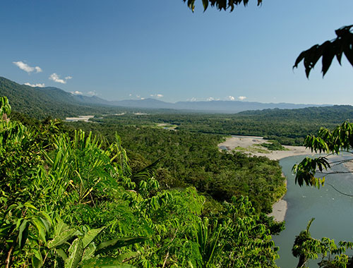
Joining another major Inca road at Yanama , we climb 3000 ft. up a precipitous trail carved carefully through the cliffs of San Juan Pass to pass by an abandoned colonial period silver mine, Mina Victoria (whose victory? we don't know). We have our first view of the immense Apurimac drainage far below. This deep canyon and its powerful river is one of the great geographic wonders of the Americas. The Apurimac which means " voice of god or mighty speaker" in Quechua, thunders hundreds of miles through the remotest part of the Andes to eventually, along with a multitude of sister rivers, become the Amazon. We follow a seemingly endless winding trail down to the small campsite of Maizal at an altitude 3000m. We bathe, and enjoy tropical warmth. A condor drifts lazily in the afternoon thermals high above B: L: D
Day 8: Maizal To Choquequirao
Following a leisurely breakfast we descend another 1200 mts into the Rio Blanco canyon famous for its nasty biting sand flies called Pumahuacachi by the locals- (literally "makes the puma cry") and to lunch at the Inca temple site of Pinchu Unuyoc. An unusual shrine to the sacred spring, which still flows through carefully, constructed stone fountains found by Barry Walker in the 1980's. This afternoon is the final 1200 my climb to our objective. By late afternoon we have reached massive stone constructions and jungle tangle within the imposing walls of an ancient ceremonial city. We set up base camp just below the Choquequirao ruins. B: L: D
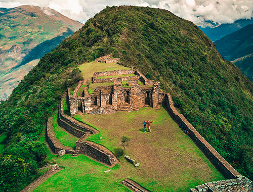
Day 9: Choquequirao
Nestled at 10,000 ft., on a prominent ridge overlooking the profound Apurimac chasm with backdrop of ice sculptured mountain cathedrals, this mythical Lost city must have rivaled Machu Picchu in beauty and importance. Little is known of this major, seldom visited, Inca site. Hiram Bingham led an expedition here in February of 1910 in search of Vilcabamba Vieja, a missing piece in the puzzle that remains of the last Inca realm. We do know that this is a fantastic, finely constructed, complex site demanding of further studies. We have a full day here to explore, film and speculate. Exploring the amazing ruins of Choquequirao with time to explore and marvel at this dramatic location nearly 1700 m above the roaring Apurimac river and the vast size of these extensive ruins in area far bigger than Machu Picchu. There is an enormous curving bank of fine terracing, a chain of ritual baths and a central plaza surrounded by fine ceremonial and high status residential architecture. Large areas still remain covered in the thick cloud forest giving an insight into how the first explorer's felt arriving at this deserted city. Its purpose is also still largely unclear as the largest of the outlying sites it is unmentioned in the chronicles and remained uncharted until the 18th century. There are several theories including: the stone-work is that of en-slaved Chachapoyans from the North – they were supposedly more than happy to burn and leave the site on the downfall of the Incas. Another is that it would have been used a main highway look-out by the last Incas during their thirty year exiled rule in Vilcabamba: this Inca road would have connected Vilcabamba to the Central Highlands whilst by-passing the Spanish in Cusco. We return to base camp below to ponder our own theories for the evening. B: L: D
Day 10: Choquequirao To Chikiski
Reluctantly departing, we descend a winding steep trail some 6000 feet down to the Apurimac River. Crossing over a swaying Inca style, cable-bridge suspended above the raging rapids, we make a bivouac camp above the river at the small settlement of Chikiska and set up camp for the night. B: L: D
Day 11: Chikiski To Cachorra and Cusco
Completing the hike out to the road head and picturesque village of Cachora, we bus back to Cusco and the comforts of a modern hotel. On the way we'll stop to visit the sculptured Sayhuite Stone. The site is regarded as a center of religious worship focusing on water. An important feature on the site is the Sahuite monolith, a rock with more than 200 geometric and zoomorphic figures. In the Monuments of the Inca by John Hemming, Hemming points to a colonial narrative that describes the interior of the Sayhuite temple. The temple featured larger columns draped in fabrics with gold bands the "thickness of one's hand. Stopping to admire the astonishing Inca stonework of little known Inca ruins of Tarahuasi, planning to arrive early at the end of an epic journey we drop you off at your hotel. We gather for farewell dinner and cold beer at a favorite restaurant. B: L: D
Included meals: B=breakfast; L=lunch; D=dinner
Season: April to December
Difficulty: Moderate/Hard

 English
 Español
 Français
 Portugués
 Deutsch